
HW3D: A tool for interactive real-time 3D visualization in GIS supported flood modelling
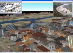
Large numerical calculations are made to get a prediction what damage a possible flood would cause. These results of the simulation are used to prevent further flood catastrophes. The more realistic a visualization of these calculations is the more precaution will be taken by the local authority and the citizens. This paper describes a tool and techniques to get a realistic looking, three-dimensional, easy to use, realtime visualization despite of the huge amount of data given from the flood simulation process.
@inproceedings{bender04,
author = {Jan Bender and Dieter Finkenzeller and Peter Oel},
title = {HW3D: A tool for interactive real-time 3D visualization in GIS supported flood modelling},
booktitle = {Proceedings of the 17th international conference on computer animation and social agents},
year = {2004},
address = {Geneva (Switzerland)},
pages = {305-314}
}
