
Level of Detail for Real-Time Volumetric Terrain Rendering
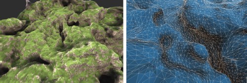
Terrain rendering is an important component of many GIS applications and simulators. Most methods rely on heightmap-based terrain which is simple to acquire and handle, but has limited capabilities for modeling features like caves, steep cliffs, or overhangs. In contrast, volumetric terrain models, e.g. based on isosurfaces can represent arbitrary topology. In this paper, we present a fast, practical and GPU-friendly level of detail algorithm for large scale volumetric terrain that is specifically designed for real-time rendering applications. Our algorithm is based on a longest edge bisection (LEB) scheme. The resulting tetrahedral cells are subdivided into four hexahedra, which form the domain for a subsequent isosurface extraction step. The algorithm can be used with arbitrary volumetric models such as signed distance fields, which can be generated from triangle meshes or discrete volume data sets. In contrast to previous methods our algorithm does not require any stitching between detail levels. It generates crack free surfaces with a good triangle quality. Furthermore, we efficiently extract the geometry at runtime and require no preprocessing, which allows us to render infinite procedural content with low memory consumption.
@inproceedings{Scholz2013,
author = {Manuel Scholz and Jan Bender and Carsten Dachsbacher },
title = {{Level of Detail for Real-Time Volumetric Terrain Rendering}},
pages = {211-218},
URL = {http://diglib.eg.org/EG/DL/PE/VMV/VMV13/211-218.pdf},
DOI = {10.2312/PE.VMV.VMV13.211-218},
editor = {Michael Bronstein and Jean Favre and Kai Hormann},
booktitle = {VMV 2013: Vision, Modeling & Visualization},
year = {2013},
address = {Lugano, Switzerland},
publisher = {Eurographics Association}
}
